




Anuja Khushu
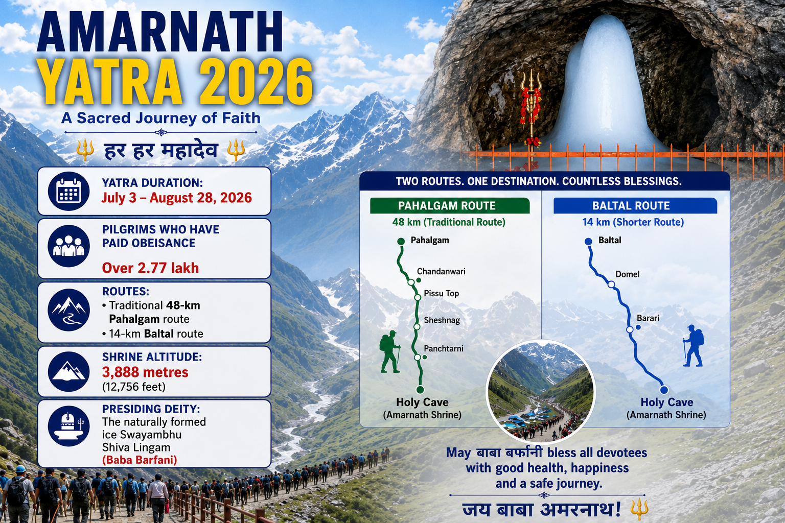
Every summer, a massive logistical mechanism swings into motion across the rugged folds of South Kashmir. Hundreds of thousands of yatris move along two highly managed corridors: the 48-kilometre traditional path winding out of Pahalgam and the steep, swift alpine ladder cut through Baltal. Guarded by columns of security personnel, track monitors, and medical camps, the modern Amarnath Yatra is experienced entirely as a linear distance between a handful of designated base camps—Nunwan, Chandanwari, Sheshnag, and Panchtarni. For today’s pilgrim, the target is singular and destination-focused: the great cave, the ice stalagmite, a brief flash of darshan, and the swift return.
Yet, buried inside the leaves of medieval Kashmiri Sanskrit literature, an entirely different sacred dimension lies hidden directly beneath the boots of modern pilgrims.
The Bhringisha Samhita and the Amarnatha Mahatmya, texts natively preserved for centuries by the Kashmiri Pandit community, detail an ancient reality. According to these scriptures, the pilgrimage was conceived not merely as a journey to a cave shrine, but as an extraordinary, multi-week spiritual expedition traversing 39 distinct, named tirthas (sacred spots), high alpine lakes, rivers, and shrines that collectively formed the grand cosmological grid known as the Nandikshetra Mahaksetra.
Today, as millions walk past these coordinates knowing only the notified four or five stops, the true ancient blueprint of this Himalayan pilgrimage remains largely untold.
Scriptural Evidence: The True Textual Record
The historical antiquity of the shrine is firmly anchored in Kashmir’s classical library, proving that the route was well-travelled and documented over a thousand years ago:
·The Nilamata Purana (c. 6th–7th Century CE): The foundational cultural and canonical text of Kashmir explicitly recognizes the high-altitude site under its pristine name, Amareshwara (Verse 1324), cataloging it as a locus of supreme spiritual energy long before medieval geography was altered.
·Kalhana’s Rajatarangini (1148–1149 CE): The legendary historian Kalhana notes in Book I (Verse 267) that the dazzling white glacial lake (Sheshnag) was actively visited by pilgrims en route to Amareshwara. In Book II (Verse 138), Kalhana records that King Samdhimat Aryaraja (34 BCE–17 CE) spent his summers in deep worship of a “linga formed of snow in the regions above the forests.”
·The Later Chronicles: The continuity of the pilgrimage across successive political eras is reflected in later chronicles. Jonaraja’s Rajatarangini records that the fifteenth-century ruler Sultan Zain-ul-Abidin (Budshah) undertook the pilgrimage to Shri Amarnathji while supervising the construction of the Martand canal along the Lidder River.
·The Mughal Era: In the 16th century, Shuka’s Rajavalipataka notes that Akbar’s Mughal Governor of Kashmir, Yusuf Khan, provided a highly detailed description of the Amarnath Yatra and its unique ice formations directly to the Emperor, confirming the route was fully operational and globally recognised.
However, none of these texts provides a step-by-step itinerary. That explicit mapping is preserved solely in the Bhringisha Samhita and its liturgical companion, the Amarnatha Mahatmya.
The Geography Paradox: The Dual Nandikshetras
A critical textual discovery that has evaded modern commentary is what scholars identify as the “Two Nandi Kshetras” of Kashmir.
In the Nilamata Purana and Kalhana’s writings, Nandikshetra is traditionally located in northern Kashmir, encompassing Mount Harmukh (Haramukh), Gangabal Lake, and the ancient temple ruins of Wangath (Bhuteshvara). This is the landscape where Nandi, the chief attendant of Shiva, performed his grueling penance standing in the freezing waters of Nundkol Lake.
Yet, the Bhringisha Samhita executes a brilliant theological translation. It expands the sanctified boundaries of Nandi Kshetra southward, mapping its cosmic properties directly onto the Lidder Valley and the Amarnath mountain system. The text introduces a dialogue where Sage Vyasa asks the celestial Sanatkumara how Nandi attained absolute immortality. Sanatkumara explains that after Sati’s self-immolation and her cosmic rebirth as Parvati, the entire high valley system became an interconnected ecosystem of energy.
Shiva himself declares in the Samhita that the land stretching from Lokadvara (the lower entryway) to Kanakanandi (the golden heights) is a singular Mahaksetra. Every ridge, pool, and stream was assigned a specific protective deity (Gana), a specialized purificatory ritual, and an ancestral debt to be cleared.
Reconstructing the Lost Map: The 39 Hidden Stations
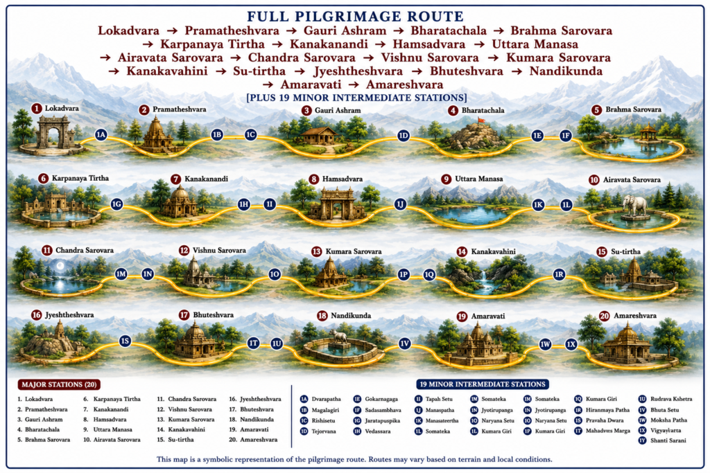
By superimposing the topographical directions of the Bhringisha Samhita and the Amarnatha Mahatmya onto modern satellite imagery and the existing Pahalgam-Baltal routes, we can finally reconstruct the 39 sacred coordinates that once guided the ancient pilgrim.
The major stations of this lost itinerary reveal a deeply structured process of spiritual ascent:
1. The Valleys of Initiation: Lokadvara to Gauri Ashram
· Lokadvara (Station 1): Literally translated as the “Gateway of the World,” this ancient frontier marks the transition out of mundane existence. Scholars identify this with the natural entry bottleneck into the lower Lidder Valley just below modern Pahalgam. The ancient yatri did not view this as a tourist town, but as a boundary of total renunciation.
· Pramatheshvara (Station 2): A shrine dedicated to the lords of Shiva’s attendants (Pramathas), where pilgrims sought spiritual clearance before ascending into the higher altitudes.
· Sindhu Tirtha (Station 3): The ritual bathing ghats located at the confluence of the mountain streams near Nunwan.
· Gauri Ashram (Station 5): Historically identified with the alpine meadows around Chandanwari, this site was revered as the specific hermitage where Parvati conducted her severe austerities to win back Shiva. The Samhita mandates explicit worship of the Goddess here on the fourth day of the bright fortnight of Bhadrapada, balancing the masculine asceticism of Shiva with the raw power of Shakti.
2. The High Vertical Ascents: Bharatachala to Karpanaya
· Bharatachala / Mount Bharata (Station 7): The imposing, vertical ridge known today to breathless pilgrims as Pissu Top (referred to in some texts as Vayuvarjan). The Samhita describes this mountain as a living pharmacy, dense with divya-aushadhi (medicinal herbs and cosmic flora). The text imposes a strict code: pilgrims were to scale it slowly, consuming only minimal, simple food, viewing the physical strain of the climb as an ethical cleansing of the body.
· Brahma Sarovara & Karpanaya Tirtha (Stations 9 & 10): Located along the high alpine flats of Zojibal and Nagakoti, these were high-altitude seasonal pools filled with alpine vegetation. The Samhita notes that even a single sip from the waters of Karpanaya could dissolve lifelong internal blockages. Today, these pools are unnamed, overlooked, or completely dried up due to climatic variations.
3. The Great Hydrological Axis: Uttara Manasa and the Seven Tarns
· Kanakanandi (Station 12): Described as an incredibly remote sanctuary guarded by serpent deities (Nagas), this corresponds to the high glacial shelves overlooking the Sheshnag basin.
· Hamsadvara (Station 14): The “Gate of the Swan,” the narrow, wind-swept mountain opening that leads directly to the great lake.
· Uttara Manasa (Station 15): The classical, original designation for Sheshnag Lake (also referenced as Susrang). The Samhita elevates this emerald-blue water body into a cosmic reservoir, claiming that a branch of the celestial Ganga descended directly into it from Shiva’s matted locks. Ancient pilgrims did not merely snap photographs and move on; they were textually commanded to camp on its freezing shores for one, three, or seven nights, performing Shraddha (ancestral rites) to liberate generations of their lineages.
· The Five Celestial Tarns (Stations 16 to 21): The text maps a dense cluster of high-altitude glacial lakes: Airavata Sarovara (named after Indra’s elephant), Chandra Sarovara, Vishnu Sarovara, Taraka Sarovara, and Kumara Sarovara. These correspond to the permanent and semi-permanent glacial tarns scattered across the high margins of the Mahagunas Pass (MG Top).
4. The Meadows of the Ancestors: Kanaka Vahini to Sutirtha
· Kanaka Vahini (Station 24): The “Golden River,” referring to the fast-flowing glacial meltwater that drops from the Mahagunas snowfields down into the high plateau of Panchtarni.
· Sutirtha (Station 27): In an absolute burst of regional pride, the Bhringisha Samhita makes a shocking claim regarding this specific location near the five streams (Panchatarangini): “Neither Ganga, nor Kurukshetra, nor Prayag, nor Pushkara equals the spiritual potency of Sutirtha.” It was viewed as the ultimate cosmic cleansing station where the spirits of the deceased attained total liberation (Moksha).
· Jyeshtheshvara & Bhuteshvara (Stations 30 & 31): Ritual rock formations and shrines located near the modern Sangam Junction, where the traditional Pahalgam track meets the Baltal route.
5. The Ultimate Apex: Amaravati to Amareshvara
· Amaravati (Station 37): The freezing, white-silt stream that flows past the base of the Amarnath cliff face. Pilgrims were required to completely immerse themselves in its chalky waters to strip away the final remnants of their earthly egos.
· Kapota Tirtha (Station 38): The station of the Kapota (the immortal pigeons). The Samhita provides the definitive theological source for this living Himalayan legend: the birds are actually transformed Ganas who quarreled during the cosmic discourse of immortality (Amar Katha). Cursed by Shiva to remain as avian guardians, their presence is so vital that the Samhita warns that any traveler who exits the cave without actively seeking sight of the birds is a Tirtha-drohi (a desecrator of the pilgrimage).
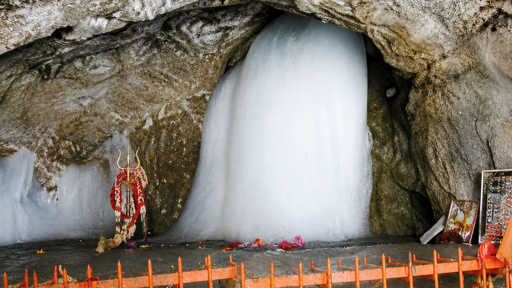
· Amareshwara (Station 39): The great cave itself. The text explicitly terms the ice formation as the Swayambhu Lingam—a self-manifested axis of the universe superior to all terrestrial shrines.
The Antiquity of the Ice Lingam & The Legend of Bhrigu
A major value of the Amarnatha Mahatmya is its empirical observation of the cave’s natural phenomena. The text systematically documents the formation of the Swayambhu ice lingam. It notes the unique cycle where the ice waxes and wanes according to the phases of the moon, culminating in its maximum size on the full moon of Shravana (Shravana Purnima). This proves that the natural lifecycle of the ice formation was well-understood and deeply integrated into Indian spiritual life long before modern scientific documentation.
Furthermore, according to the narrative embedded in the Mahatmya and supporting Kashmiri Puranas, the discovery of the holy cave belongs to deep antiquity. The texts describe a time when the valley of Kashmir was a massive primal lake. After the great sage Kashyapa drained the waters, the high mountain passes became accessible. It was the great sage Bhrigu who, while traveling through these newly uncovered heights, became the first human to discover the cave, witness the magnificent ice formations, and experience the first darshan of the deity.
The Anatomy of the Contracted Route
Why did a multi-week, 39-station sacred ecosystem contract into the highly compressed, linear trek we see today? The historical causes are threefold:
1. Climatic and Landscape Instability: The high-altitude terrain between 11,000 and 14,000 feet is highly dynamic. Landslides, avalanches, flash floods, and accelerated glacial retreats have physically altered the landscape, burying small springs and drying up seasonal sarovaras.
2. The Rise of Democratic Mass Pilgrimage: The transformation of the yatra from an elite, ascetic pilgrimage into a massive national event involving over 400,000 people necessitated a shift in administrative strategy. The state’s priority is safety, medical tracking, and crowd throughput. Modern infrastructure naturally funnels crowds along tightly secured lines, causing the unnotified intermediate shrines to recede into obscurity.
Heritage Reclamation: A Blueprint for the Future
While the rich textual geography of the Nandikshetra remains largely absent from contemporary narratives surrounding the pilgrimage, the current reality of the Amarnath Yatra presents a historic opportunity for cultural recovery. Restoring the memory of the 39 tirthas does not require changing the modern security grid or disrupting administrative routes. Instead, it invites an interdisciplinary collaboration between Sanskrit scholars, geographers, archaeologists, and the Shri Amarnathji Shrine Board:
· Digital GIS Mapping: Using modern Geographic Information Systems (GIS) to correlate the descriptions in the Bhringisha Samhita with the physical landscape of the Lidder Valley and the upper Himalayan terrain leading to the Amarnath Cave, helping identify forgotten tirthas, alpine lakes, and other sacred landmarks.
· On-Site Heritage Interpretation: Erecting educational panels at the major base camps (Pahalgam, Chandanwari, Sheshnag, Panchtarni, and Baltal) to brief contemporary yatris on the ancient names and underlying spiritual philosophies of the soil they are standing on.
· Restoring Hydrological Respect: Shifting the narrative from a standard high-altitude trek back to a profound respect for the fragile alpine water systems (Sarovaras) that the ancient texts sought to protect through ritual sanctification.
As the chants of Mahadev echo through the mountain passes this season, the ancient text of the Bhringisha Samhita reminds us that the true majesty of Amarnath is not just found at the final cave walls. It lives in every forgotten stream, every holy ridge, and every hidden step of the vast, sacred landscape that has waited centuries to be remembered once more.